Point Of Interest (POI) Auto Map
- Last Update
- 11 January 2013
- Regular License
- $12
- Extended License
- $60
- Sales
- 1183
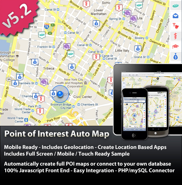
Create Location Aware Sites In Minutes Poi Auto Map combines the power of Google’s Maps and Places APIs to give you a simple way to add highly interactive Point of Interest maps to your website. All you need to do is define a starting address and a list of point of interest categories and POI Auto Map does the rest. Move the map and watch the points update. You can also define a database connection from which to source your POI points. This is the largest update yet in both features and performance. Works well in any website as an add on or as a mobile / touch website on its own. See a working example here: http://api.australele.com/local/v5.2/ See a working mobile / geolocation example here: http://api.australele.com/local/v5.2/mobile/ New In Version 5.2 (10/1/2013):
Option to include Google Places Photo in InfoWindow (Marker Bubble) Option to include Google Places Ratings in InfoWindow (Marker Bubble) Improved InfoWindow Linking POI title now links to the poi’s website if they have one (instead of Google Places page)
Minor Interface Improvements New In Version 5.1 (27/1/2012):
Language / Region Selection Directions Mode Selection Interface enhancements
New In Version 5.0:
Google Places Integration
Access Google Place Information Use Google Places Types Combine Types with search by name for more granular results. Returns multiple results limited only by search radius setting. Uses JSON result set for best performance Can use Googles POI icons for places locations
Geolocation – Location Aware
Automatically find your current location Ideal for Mobile Applications
Mobile / Full Screen Example Included
Includes JS / HTML and CSS Works well on ios / android / wm, phones and tablets
Have infowindow content be shown in an external DIV instead on the standard info window bubble
Improved Interface Scrolling Categories List Expand / Collapse Categories List
Database Performance
Database records are now returned as JSON. Significantly faster for large record sets.
Removed Items
Panoramio and Wikipedia Layers XML File Processing
New In Version 4.0:
Google Maps API v3.0
Re written for Google Maps API v3.0 keyless api faster mapping / geocaching
Removed XML file processing
External Info Window
New In Version 3.0:
Database connector
Add Markers to the map from your own database Assign custom marker icons to each group or each individual point Add your own custom HTML to the marker point’s popup Street View and Driving Directions Included Only markers from the database that are on the current map area are loaded – better speed. Batch / Bulk Geocoding tool included – convert addresses to latitude, longitude pairs Must be running PHP 5.1 or better and MySQL
User Printable Street Directions
Customize what gets printed with your own logo
v2.0 Features:
Integrated Streetview User Search categories Search for locations Photo and wikipedia layers Simple Integration 100% Native Javascript – No Jquery, MooTools, etc Fully CSS stylable Full Documentation Included Full Geocoding – Just provide an address. No messing with Latitude and Longitude Dynamic results – no DB or data entry required if you don’t want to connect to a database
Perfect For:
Location Based Services Mobile Direction Sites Creating an advanced Location / Contact page on your site Realtor / Estate Agents Community Guides Restaurant Guides Photo Galleries