MapSVG: Interactive Vector Maps
- Last Update
- 12 May 2013
- Regular License
- $17
- Extended License
- $85
- Sales
- 857
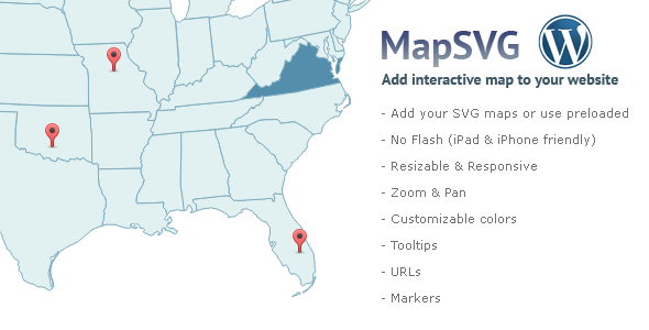
MapSvg plugin can take any SVG map and make it interactive. jQuery version of the plugin also available.
Need support? Please click here! (support in comments isn’t being provided)
Latest update: May 12 2013, version 1.5.5 Don’t forget to come back for updates with new features.
Features
Any maps – works with almost any SVG map; you can get free SVG maps at Wikipedia. Preloaded maps – World, USA , Russia, Europe, Africa, Australia, Germany, Peru, Brazil, Malaysia, South Easth Asia No Flash – works on iPad & iPhone Cross-browser – tested Resizable – just set width / height Responsive – auto-adjust size for small screens Zoom & pan – optional (on/off) zoom & pan – zoom with mousewheel, scroll by mouse pointer Customizable Colors – base, hover, selected, disabled, strokes; Regions as clickable links – set URLs for regions Tooltips – show country names or custom text Markers – put markers to the map – set custom image, tooltip, href Custom event handlers – onClick, onMouseOver, onMouseOut Friendly Control Panel (works fast on ajax without page reloading)
Main Setting
Colors
Regions
Markers
Markers [edit]
Events
Control panel works on jQuery + Ajax: fast switch between tabs and save without page reloading.
Shortcode After you have finished setup of map in control panel, just add a small shortcode to any page: [mapsvg id=6]. You can have unlimited number of maps, each will have unique ID for a shortcode.