MyPlistMap for iPhone & iPad
- Last Update
- 3 January 2012
- Regular License
- $25
- Extended License
- $125
- Sales
- 150
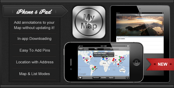
MyPlistMap allows you to add hundreds of annotations to your map, without even updating your application!
Updated on December 23rd, 2011 (Version 2.0)
Make sure you’ve updated your project with the awesome new features I’ve added in version 2.0! How does it work?
MyPlistMap comes with a property list (.plist) that holds all your annotations. Whenever you open the app from your iOS device, the .plist file is remotely downloaded from your server, which means that you don’t have to update your application in order to add new places to your map. Without MyPlistMap, if you had to add a new pin to your map, you needed to submit a new update of your app to Apple Inc. This is over. Thanks to MyPlistMap, you just drag & drop your updated .plist file to your server and your customers will instantly get the latest annotations! Your annotations are displayed on both a map and a list. Users can switch from map mode to list mode using a built-in switcher. Each annotation can include as much information as you want. In a few seconds, you can add a description, a postal address, a phone number, a webpage link, an email address… Or whatever you need. When you press a pin on the map, they are displayed in the detail view. Adding to the ability of having information about a place, you can add a picture to illustrate it! The picture is downloaded from your server as well, so you don’t have to update your app to add a picture. When pressing the location button, user’s address is displayed based on his location!
Compatibility
MyPlistMap is a Universal project, tested and working for iPhone, iPod Touch & iPad.
MyPlistMap works in both Portrait & Landscape modes.
MyPlistMap has been updated to fully support iOS 5.
Key Features
In order to show you how MyPlistMap works, I created a default .plist file, with annotations from the Top 22 World’s Largest City ranked by population. Out of the box, you get 7 pieces of information for each pin: city’s name, state, country, population, pin’s color, latitude & longitude. Obviously, you can replace them easily with the most relevant information for your own project. When you first open the app, a UIProgressView is displaying the download progress of the .plist file. Once the file has been downloaded, users can open the map to see the freshly updated annotations. The MKMapView is controlled by a built-in UISegmentedControl, in order to switch the Map Type to Standard, Satellite or Hybrid. When pressing the location button, user’s address is displayed based on his location! You can choose the color of each pin on the Map (red, green & purple by default). A built-in UITableView is used to display your places in a list. You can switch from map mode to list mode with ease, using another UISegmentedControl. If you select a pin, this will open a detail view, which includes every pieces of information you added for your place in your .plist file. For each place, you can even have a picture, which is also downloaded from your server! If you’d rather load your annotations or your images locally, the code is also included in MyPlistMap.
If you have any question about this Xcode project, feel free to contact me at Nicolas(at)Spehler(dot)com.
Don’t forget to rate & comment!
Updates Version 1.0 (August 1st, 2011) First release of MyPlistMap for iPhone, iPod Touch & iPad. Version 2.0 (December 23rd, 2011)
Added support for images. User’s address is now displayed based on his location. Improved GPS accuracy. Improved performances. Bug correction.
Nicolas Spehler