MyMap for iPhone & iPad
- Last Update
- 4 May 2011
- Regular License
- $16
- Extended License
- $80
- Sales
- 53
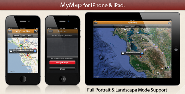
MyMap allows you to get your own map into your iPhone & iPad application! How does it work? Basically, the map includes many annotations. You can select an annotation in order to display a detail view of your pin/annotation.
In the detail view, a Google Maps engine is included. You can press the ‘Open in Google Maps’ button in order to open your point of interest in the native Maps application.
We provide you two XCode projects:
MyiPhoneMap for iPhone & iPod Touch.
MyiPadMap for iPad & iPad 2.
Key Features:
MKMapView with annotations that you can add with ease. 2 pins are already set up for you, but you just have to follow commented instructions in order to add as many pins as you wish.
The MKMapView is controlled by a built-in UISegmentedControl, in order to change the Map Type from Standard, Satellite & Hybrid.
You can choose the color of your pins.
If you select a pin, this will open a custom detail view.
Add a title & a subtitle to your pins.
Open your points of interest within native iOS application, Google Maps.
Once the user press the ‘Open in Google Maps’ button, a UIPopover (on the iPad) or an UIActionSheet (on the iPhone) will be displayed in order to ask the user confirmation to quit your app in order to open Google Maps.
Full Portrait & Landscape mode support.
If you have any question about this Xcode project, feel free to contact me at Nicolas(at)Spehler(dot)com.
Don’t forget to rate & comment!
Changes from previous versions: Version 1.0 First release of MyMap for iPhone & iPad.
Nicolas Spehler
